undefined
Similar Products


Description
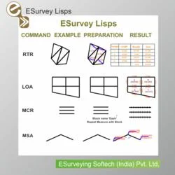
ESurvey Lisps provide a curated suite of automation routines for CAD platforms like AutoCAD, BricsCAD, GStarCAD, and ZwCAD. This collection addresses the common need for reliable, ...
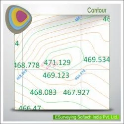
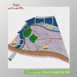
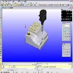
ESurvey Lisps provide a curated suite of automation routines for CAD platforms like AutoCAD, BricsCAD, GStarCAD, and ZwCAD. This collection addresses the common need for reliable, well-documented tools that go beyond basic CAD functions. Developed with input from industry professionals, it offers a centralized menu system for easy access to over 18 categories of macros. Each routine is thoroughly tested to ensure stability and seamless integration into daily drafting and design workflows. It eliminates the uncertainty of using untested scripts, giving drafters, engineers, and surveyors a trusted toolkit to work more efficiently and with greater confidence.

This product is essential in fields where precision and efficiency directly impact project success. Land surveyors use it for parcel area calculations, traverse adjustments, and generating elevation data. Civil engineers apply these tools for road design, utility mapping, and earthwork calculations, streamlining infrastructure projects. Urban planners and environmental consultants rely on the lisps for topographic modeling, site analysis, and preparing accurate base maps. Municipal agencies and large engineering firms benefit from the bulk processing capabilities, which ensure consistency and compliance across extensive project deliverables, from initial surveys to final construction drawings.

The value of ESurvey Lisps lies in its proven ability to reduce project timelines and minimize costly errors. By automating routine tasks, it allows professionals to focus on complex design challenges, enhancing overall drawing quality and client satisfaction. Its reliability is built on rigorous testing and clear documentation, reducing technical support needs and downtime. The tools provide a tangible return on investment by increasing drafting throughput and accuracy. For firms looking to optimize their CAD operations, it represents a strategic asset that delivers long-term productivity gains and a competitive advantage in delivering precise, timely work.

Key Features:
- Centralized menu providing organized access to all survey and drafting automation macros.
- Comprehensive suite of routines for text manipulation, including alignment, rotation, and value editing.
- Robust tools for geometry handling, such as polyline conversion and 3D point generation.
- Efficient layer management and object selection utilities for streamlined drawing organization.
- Data import and export functions, including CSV data handling and batch printing operations.

Benefits:
- Significantly reduces time spent on repetitive manual drafting and data entry tasks.
- Enhances drawing consistency and quality by standardizing outputs and reducing human error.
- Increases project throughput and enables faster turnaround times for client deliverables.
- Lowers the risk of inaccuracies in calculations and data reporting for surveys and plans.
- Provides a reliable, tested alternative to unstable or poorly documented free scripts.
Specifications
| Additional Information | |
|---|---|
| Country of Origin | India |
| Customisable | No |
Application
ESurvey Lisps are designed for professionals in surveying, civil engineering, and construction who need to automate repetitive CAD tasks. These routines handle text alignment, polyline conversion, and data export, reducing manual effort and standardizing outputs for land development, infrastructure design, and mapping projects. They ensure consistency and accuracy across all drawings.

Industries including urban planning, environmental consulting, and utility management use these tools for precise data handling and compliance. The lisps support complex calculations, layer management, and bulk processing, integrating seamlessly into professional workflows. This improves project turnaround times and delivers reliable results for large-scale developments and detailed site analysis.
- Automate text justification and rotation in survey drawings to maintain uniform presentation.
- Convert connected lines to polylines and calculate cumulative distances for accurate land parcel measurement.
- Generate 3D points and elevation labels from survey data for creating detailed topographic models.
- Export selected object data or text values to CSV files for further analysis and reporting.
- Perform bulk printing and scaling of multiple drawings to meet specific project submission standards.
Trade Details
| Available Stock | In stock |
| Sample Availability | No |
Payment Terms
| Payment Terms |
|
Company Profile

E Surveying Softech ( India ) Private Limited, Karnataka
 Karnataka, India
Factory Details
Factory SizeBelow 1000 sqm
Annual Production Capacity0
Main Markets
South Asia
CAD Surveying Automation ESurvey Lisps For AutoCAD BricsCAD GStarCAD ZwCAD
ESurvey Lisps are reliable CAD automation routines for AutoCAD, BricsCAD, GStarCAD, and ZwCAD. Enhance survey drawing productivity with tested tools for text, polyline, and data management, saving time and ensuring quality.
Min. Order Quantity: 1 units
Shipping
Shipping fee and delivery date to be negotiated. Contact supplier now for more details.
E Surveying Softech ( India ) Private Limited Karnataka, India