undefined
Similar Products


Description
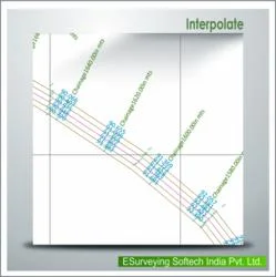
ESurvey Interpolate is a specialized software solution designed to automate the interpolation of elevation values between surveyed points, addressing a common challenge in geospati...
ESurvey Interpolate is a specialized software solution designed to automate the interpolation of elevation values between surveyed points, addressing a common challenge in geospatial and engineering workflows. Traditional methods often require manual calculations, which are time-consuming and prone to errors. This software streamlines the process by applying proven mathematical techniques to generate accurate values at regular intervals along alignments, such as longitudinal sections and cross-sections. It supports data export to Excel, enabling seamless integration with other tools for section generation, reporting, and further analysis. By reducing manual effort, ESurvey Interpolate enhances productivity and ensures consistency in data processing for professionals dealing with terrain modeling and alignment design.

This software is widely used in industries that rely on precise elevation data, including civil engineering, construction, land surveying, and infrastructure development. In civil engineering, it aids in road, railway, and pipeline projects by providing interpolated values for design and planning. Surveyors use it to fill gaps in field data caused by inaccessible terrain or logistical constraints. Environmental consultants apply it for terrain analysis in studies related to drainage, erosion control, and land use planning. Additionally, mining and quarrying operations utilize the software for volume calculations and site modeling. Its flexibility makes it suitable for both large-scale infrastructure projects and smaller site-specific applications, ensuring accuracy across diverse scenarios.

The business value of ESurvey Interpolate lies in its ability to improve efficiency, reduce costs, and enhance reliability. By automating interpolation, it minimizes human error and accelerates project timelines, allowing teams to focus on higher-value tasks. Its compatibility with Excel and other software tools ensures easy adoption into existing workflows, reducing training needs and integration challenges. The software's use of three proven methods—straight line, TIN, and 3D interpolation—provides flexibility and accuracy, catering to different project requirements. This reliability builds trust among users, making it a dependable choice for serious buyers who prioritize precision and time savings in their operations.

Key Features:
- Automates elevation interpolation using straight line, TIN, or 3D methods
- Exports interpolated cross-section and longitudinal values directly to Excel
- Generates accurate elevation data at user-defined intervals along alignments
- Creates 3D polylines by selecting elevation texts for enhanced visualization
- Integrates seamlessly with section generation software and existing workflows

Benefits:
- Saves significant time by eliminating manual calculation processes
- Reduces human error and ensures data consistency across projects
- Accelerates project timelines through automated data processing
- Provides flexibility with multiple interpolation methods for different needs
- Enhances decision-making with accurate, reliable elevation data
Specifications
| Additional Information | |
|---|---|
| Country of Origin | India |
| Customisable | No |
Application
ESurvey Interpolate is essential for civil engineers, surveyors, and construction professionals who need precise elevation data between measured points. It eliminates manual calculations by automating interpolation, ensuring consistent and reliable results for terrain modeling and alignment planning. This tool is particularly valuable when field surveying at regular intervals is impractical due to terrain constraints or project timelines.

Industries such as civil engineering, land surveying, infrastructure development, and environmental consulting rely on this software for accurate data processing. It supports projects like road construction, pipeline routing, and site development by generating elevation values at user-defined intervals, which can be seamlessly exported to Excel or other section generation tools for further analysis and reporting.
- Generating elevation points for road and railway alignment design in civil engineering projects
- Creating accurate cross-sections for pipeline and utility routing across uneven terrains
- Supporting land development projects by interpolating survey data for grading and drainage planning
- Enhancing environmental impact studies with precise terrain models from limited survey points
- Facilitating construction layout by providing regular interval data for machine control and excavation planning
Trade Details
| Available Stock | In stock |
| Sample Availability | No |
Payment Terms
| Payment Terms |
|
Company Profile

E Surveying Softech ( India ) Private Limited, Karnataka
 Karnataka, India
Factory Details
Factory SizeBelow 1000 sqm
Annual Production Capacity0
Main Markets
South Asia
Survey Data Elevation Interpolation Software For Civil Engineers
ESurvey Interpolate software automates elevation interpolation for civil engineers using proven methods like straight line, TIN, or 3D. Export results to Excel for accurate cross-section and longitudinal analysis, saving time and reducing manual errors.
Min. Order Quantity: 1 units
Shipping
Shipping fee and delivery date to be negotiated. Contact supplier now for more details.
E Surveying Softech ( India ) Private Limited Karnataka, India