undefined
Similar Products


Description
Our professional demarcation survey services deliver precise boundary identification specifically designed for transport and logistics infrastructure projects. Utilizing advanced G...
Our professional demarcation survey services deliver precise boundary identification specifically designed for transport and logistics infrastructure projects. Utilizing advanced GPS technology and total station equipment, we provide accurate property line verification that meets all regulatory standards while supporting your development planning needs. These reliable surveys ensure full compliance with local regulations while preventing legal disputes over land boundaries, making them essential for businesses involved in construction, expansion, or acquisition of transport facilities. We employ proven methodologies adapted to various terrain conditions and project requirements, ensuring timely delivery without compromising accuracy or attention to detail.

These demarcation surveys serve multiple sectors within the transport industry, including highway development authorities, railway corporations, port operators, and logistics companies. They prove critical for road construction projects requiring right-of-way verification, railway expansion needing corridor boundary establishment, and port infrastructure development demanding precise land measurements. Warehouse developers and transport terminal operators consistently rely on our surveys for land acquisition compliance and construction planning, ensuring all projects adhere to local regulations while avoiding boundary-related disputes that could delay progress and increase costs.

We deliver exceptional value through cost-effective survey solutions that reduce project delays and provide reliable data for investment decisions. Our extensive industry experience ensures we understand the unique challenges of transport infrastructure projects, combining advanced technology with expert analysis to deliver trustworthy results. The surveys offer peace of mind by preventing legal complications, ensuring regulatory compliance, and supporting smooth project execution from initial planning through final completion stages, ultimately protecting your investment and timeline.

Key Features:
- Advanced GPS and total station technology for precise measurements
- Comprehensive boundary marker installation and documentation
- Detailed survey maps meeting all regulatory standards
- Customized methodologies for various terrains and project scales
- Regulatory compliance assurance across all jurisdictions

Benefits:
- Prevents legal disputes and boundary conflicts
- Ensures regulatory compliance and approval processes
- Reduces project delays and associated costs
- Provides reliable data for investment decisions
- Supports smooth project execution from planning to completion
Specifications
| Additional Information | |
|---|---|
| Country of Origin | India |
| Customisable | No |
Application
Our demarcation survey services provide precise boundary identification essential for transport infrastructure development and expansion projects. They deliver legal clarity and prevent land disputes during critical construction phases, land acquisition, and regulatory approvals. These professional surveys support informed decision-making for logistics parks, highway expansions, and port developments by ensuring accurate land data and compliance with local regulations.

Tailored for transport and logistics sectors requiring reliable boundary verification, our services serve highway authorities, railway corporations, port operators, and warehouse developers needing exact property limits. The surveys adapt to various terrains and project scales while maintaining accuracy and regulatory adherence throughout the entire process, providing consistent results across different environmental conditions and project requirements.
- Highway and road construction right-of-way verification
- Railway corridor boundary establishment for expansion projects
- Port and harbor infrastructure development planning
- Logistics park and warehouse facility land acquisition
- Transport terminal and depot construction boundary compliance
Trade Details
| Available Stock | In stock |
| Sample Availability | No |
Payment Terms
| Payment Terms |
|
Company Profile
Dhyani Consultants Inc., New Delhi
 New Delhi, India
Electronics & Electrical•Distributor / WholesalerRetailerImporter / Exporter
Factory Details
Factory SizeBelow 1000 sqm
Annual Production Capacity0
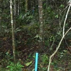
Transport Logistics Demarcation Survey Services Boundary Identification
Professional transport logistics demarcation survey services deliver accurate boundary identification for infrastructure projects. Our reliable surveys ensure regulatory compliance and prevent land disputes using advanced measurement technology.
Min. Order Quantity: 1 units
Shipping
Shipping fee and delivery date to be negotiated. Contact supplier now for more details.
Dhyani Consultants Inc. New Delhi, India
Electronics & ElectricalDistributor / Wholesaler