undefined
Similar Products


Description
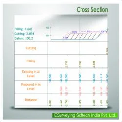
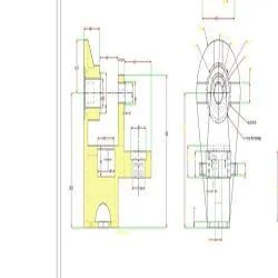
ESurvey Sections is a dedicated CAD software solution engineered for civil engineers and surveyors, specializing in the creation of precise cross-section and longitudinal section d...
ESurvey Sections is a dedicated CAD software solution engineered for civil engineers and surveyors, specializing in the creation of precise cross-section and longitudinal section drawings. It automates complex area and volume calculations, which are fundamental for infrastructure projects such as roads, railways, pipelines, and irrigation systems. The software supports data import from multiple sources including Excel spreadsheets, CAD files, and field survey books, ensuring a smooth integration into existing project workflows. Its intuitive interface and robust calculation engines provide professionals with the tools needed to produce industry-standard drawings and reliable reports efficiently, reducing manual effort and minimizing errors from the initial design phase through to final reporting.

This software is extensively utilized across various sectors within the infrastructure domain. Civil engineering consultancies and surveying firms rely on it for detailed project design and documentation. Government infrastructure departments and public works agencies employ it for planning and monitoring large-scale transportation and utility projects. Construction and contracting companies use it to manage earthwork quantities, prepare bids, and ensure accurate execution on site. Its capability to handle projects from roadways and rail networks to water management systems and urban drainage makes it a versatile tool for any professional involved in the planning, design, or construction of physical infrastructure, meeting rigorous regulatory and international standards.

The business value of ESurvey Sections is rooted in its reliability, precision, and efficiency, which directly translate to cost savings and project confidence. By automating critical drawing and calculation tasks, it accelerates project timelines, enhances resource planning, and improves overall profitability. Its proven accuracy supports confident decision-making for tenders and client deliverables. The software's unique differentiators include advanced area calculation methods, dynamic section editing, and seamless compatibility with industry-standard data formats, providing users with a dependable and competitive advantage in delivering high-quality engineering solutions.

Key Features:
- Import survey and design data from Excel, CAD files, and field books for section creation.
- Extensive customizable settings for section properties including colors, scales, heights, and text.
- Design and edit complex profiles and shapes for roads, railways, canals, and other infrastructures.
- Generate detailed area and volume calculation reports in Excel and CAD using Trapezoidal or Nett Area methods.
- Export finalized section drawings and data to multiple formats like Excel and CAD for sharing and printing.

Benefits:
- Saves significant time and reduces errors by automating complex sectional drawings and calculations.
- Enhances project accuracy with reliable tools for precise earthwork and material quantity estimations.
- Improves workflow efficiency through seamless integration with common data sources and platforms.
- Supports informed decision-making for tenders and construction with professional, compliant reports.
- Provides a versatile and reliable solution suitable for a wide range of infrastructure project types.
Specifications
| Additional Information | |
|---|---|
| Country of Origin | India |
| Customisable | No |
Application
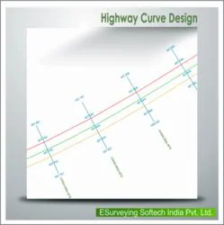
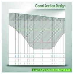
ESurvey Sections is essential for civil engineering and land surveying professionals who require accurate sectional drawings and volumetric calculations. It is specifically designed to support large-scale infrastructure projects, including road construction, railway development, and pipeline routing, ensuring high precision and adherence to technical standards for planning and execution phases.

This software integrates seamlessly with common platforms like Excel and CAD, making it a reliable tool for engineering firms, government departments, and construction companies. It facilitates efficient data import/export, allows for dynamic modifications to sections, and generates professional reports critical for project tenders, approvals, and on-site management, streamlining the entire design workflow.
- Road construction and highway development for generating cross-sectional drawings and calculating earthwork volumes.
- Railway line projects to design alignments, profiles, and accurately determine cut and fill requirements.
- Irrigation and canal system planning, including designing sections and managing water flow profiles.
- Pipeline and utility route projects for planning trenches, designing sections, and estimating material quantities.
- Sewer and drainage network projects to create line sections, calculate slopes, and generate excavation reports.
Trade Details
| Available Stock | In stock |
| Sample Availability | No |
Payment Terms
| Payment Terms |
|
Company Profile

E Surveying Softech ( India ) Private Limited, Karnataka
 Karnataka, India
Factory Details
Factory SizeBelow 1000 sqm
Annual Production Capacity0
Main Markets
South Asia
Civil Engineering CAD Software For Survey Sections And Volume Calculations
ESurvey Sections is professional CAD software for civil engineers and surveyors, enabling precise cross-section and longitudinal drawings for roads, railways, and pipelines with automated area and volume calculations.
Min. Order Quantity: 1 units
Shipping
Shipping fee and delivery date to be negotiated. Contact supplier now for more details.
E Surveying Softech ( India ) Private Limited Karnataka, India