undefined
Similar Products


Description
ESurvey Sections represents a comprehensive section creation and management solution specifically engineered for civil engineers, surveyors, and infrastructure designers. This adva...
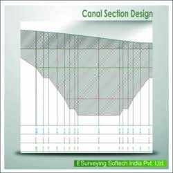
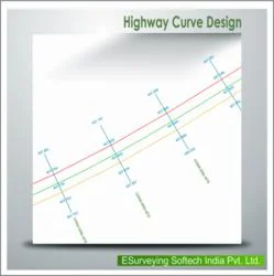
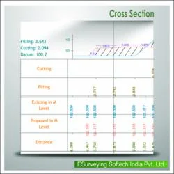
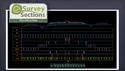
ESurvey Sections represents a comprehensive section creation and management solution specifically engineered for civil engineers, surveyors, and infrastructure designers. This advanced software enables professionals to generate industry-standard cross-sectional drawings and instant calculation reports with exceptional precision. It supports multiple data import formats including Excel spreadsheets, CAD alignment data, and field book measurements, ensuring flexibility in project data handling. The platform offers extensive customization options for section properties, presentation elements, and output formats, making it adaptable to various project requirements and organizational standards. Its intuitive interface reduces the learning curve while maintaining powerful computational capabilities for complex engineering calculations.

The software serves critical functions across multiple industries including transportation infrastructure, water resource management, and urban development. Civil engineering firms utilize it for road and highway projects, calculating earthwork volumes and optimizing terrain modifications. Railway engineers rely on its precision for track alignment and grading calculations. Water resource sectors apply it to irrigation canal design, pipeline routing, and sewer network planning. Government infrastructure departments, private construction companies, and consulting engineering firms consistently choose this solution for its reliability in meeting regulatory standards and project specifications across diverse geographical conditions and project scales.

ESurvey Sections delivers significant business value through time savings, error reduction, and enhanced project accuracy. The software's reliability is proven through its adoption by major infrastructure projects and its compatibility with industry-standard CAD packages including AutoCAD, BricsCAD, and ZWCAD. Its unique quality lies in the ability to handle complex profiling requirements while maintaining user-friendly operation. The customization options allow organizations to tailor outputs to specific project requirements and client preferences, creating a competitive advantage in bidding processes and project delivery. The software's consistency in generating accurate volumetric calculations directly impacts project costing and resource allocation decisions.

Key Features:
- Import data from Excel, CAD alignment files, and field book measurements for cross section generation
- Extensive section settings with customizable properties including colors, heights, and display elements
- Design complicated profiles and shapes for various requirements including roads and irrigation systems
- Generate area and volume reports in Excel and CAD using Trapezoidal or Nett Area methods
- Export section data to Excel and CAD formats while maintaining alignment accuracy

Benefits:
- Import data from Excel, CAD alignment files, and field book measurements for cross section generation
- Extensive section settings with customizable properties including colors, heights, and display elements
- Design complicated profiles and shapes for various requirements including roads and irrigation systems
- Generate area and volume reports in Excel and CAD using Trapezoidal or Nett Area methods
- Export section data to Excel and CAD formats while maintaining alignment accuracy
Specifications
| Additional Information | |
|---|---|
| Country of Origin | India |
| Customisable | No |
Application
ESurvey Sections is essential for civil engineering and land surveying professionals who require accurate cross-sectional analysis and volumetric calculations. It supports major infrastructure projects including road construction, railway development, pipeline networks, irrigation systems, and urban sewer planning. The software integrates seamlessly with Excel and popular CAD platforms, making it a versatile tool for field data processing and design validation.

This solution is trusted by engineering firms, government departments, and construction companies for its reliability in handling complex terrain data and generating compliant documentation. It reduces manual calculation errors and accelerates project timelines from planning to execution phases. The software's adaptability makes it suitable for both small-scale surveys and large infrastructure developments across various geographical conditions.
- Road construction projects for calculating cut and fill volumes between alignment points
- Railway track design and earthwork quantification for new line development
- Irrigation canal design and water flow capacity calculations for agricultural projects
- Pipeline route planning and trench volume estimation for oil, gas, and water networks
- Sewer system design and excavation volume calculations for municipal infrastructure projects
Trade Details
| Available Stock | In stock |
| Sample Availability | No |
Payment Terms
| Payment Terms |
|
Company Profile

E Surveying Softech ( India ) Private Limited, Karnataka
 Karnataka, India
Factory Details
Factory SizeBelow 1000 sqm
Annual Production Capacity0
Main Markets
South Asia
Civil Engineering Cross Section Calculation Software For Roads And Pipelines
ESurvey Sections is professional cross section calculation software for civil engineers and surveyors. It creates precise drawings and instant volume reports for roads, railways, pipelines, and irrigation projects with high accuracy and reliability.
Min. Order Quantity: 1 units
Shipping
Shipping fee and delivery date to be negotiated. Contact supplier now for more details.
E Surveying Softech ( India ) Private Limited Karnataka, India