undefined
Similar Products


Description
ESurvey Contour Software is a specialized tool designed for professionals in engineering, surveying, and construction industries, enabling efficient generation of smooth and accura...
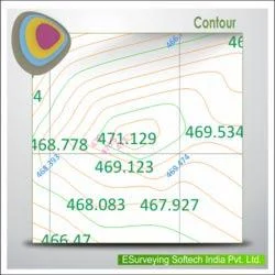
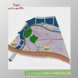
ESurvey Contour Software is a specialized tool designed for professionals in engineering, surveying, and construction industries, enabling efficient generation of smooth and accurate contours from point data sourced from CAD drawings, Excel spreadsheets, or CSV files. It eliminates the need for manual terrain creation, offering a streamlined solution for terrain mapping, volume calculations, and elevation modeling. Compatible with major CAD platforms like AutoCAD, ZW CAD, and BricsCAD, it integrates seamlessly into existing workflows, ensuring precision and reliability. Features such as instant contour area and volume generation, detailed layerization, and lightweight output files enhance productivity while maintaining high data integrity, making it indispensable for projects demanding accurate terrain analysis.

This software finds extensive use in civil engineering, land surveying, mining, and urban planning sectors. Civil engineers rely on it for site development, road design, and drainage planning, while surveyors utilize it for topographic mapping and boundary delineation. In mining operations, it aids in volume calculations for effective resource management, and environmental consultants apply it for terrain analysis and impact assessments. Its versatility extends to infrastructure projects, where contour accuracy is critical for alignment fixing and grading plans. The tool's capability to handle diverse data formats and produce industry-standard outputs makes it a preferred choice for large-scale and complex projects, ensuring consistent results across various applications.

ESurvey Contour Software delivers significant business value by reducing project timelines and minimizing errors through automation, enhancing operational efficiency. Its reliability stems from robust algorithms that ensure smooth contours and accurate volumetric data, reducing rework and associated costs. Key differentiators include the ability to generate boundary-based contours and annotate at specified intervals, catering to unique project requirements. The software's lightweight nature prevents drawing file bloating, improving performance and collaboration. By enabling single-step processes for multiple outputs like grid elevations and annotations, it boosts productivity, making it a trustworthy investment for businesses aiming to improve accuracy and client satisfaction in terrain-related projects.

Key Features:
- Import data from CSV, Excel, or CAD for contour generation.
- Generate contours directly within CAD drawings with alignment fixing.
- Instantly calculate contour area and volume for accurate terrain analysis.
- Create boundary-based contours and contours for specific levels as required.
- Annotate contours at endpoints, mid-points, selected points, or specified intervals.

Benefits:
- Streamlines terrain mapping by automating contour generation from multiple data sources.
- Enhances accuracy in volume calculations and elevation modeling for reliable project outcomes.
- Reduces manual drafting time and minimizes errors, boosting overall productivity.
- Supports seamless integration with CAD platforms, ensuring smooth workflow compatibility.
- Prevents file bloating with lightweight outputs, improving performance and collaboration.
Specifications
| Additional Information | |
|---|---|
| Country of Origin | India |
| Customisable | No |
Application
ESurvey Contour Software transforms point data from CAD, Excel, or CSV files into accurate contour maps and volumetric calculations, essential for terrain modeling in engineering and surveying. It streamlines project workflows by reducing manual drafting time and ensuring data precision across various platforms, making it ideal for construction, mining, and environmental planning. This tool supports efficient site analysis and design phases, enhancing productivity for professionals handling complex land development tasks.

Widely adopted in civil engineering, land surveying, and infrastructure development, this software delivers reliable outputs for topographic mapping and earthwork optimization. Its ability to handle diverse data formats and produce industry-standard contours makes it versatile for urban planning, resource management, and zoning compliance. By enabling quick generation of elevation grids and boundary-based contours, it aids in precise project execution, minimizing errors and supporting compliance with regulatory requirements.
- Generating detailed contour maps for site planning and land development projects.
- Calculating cut and fill volumes for earthwork optimization in construction and mining.
- Creating elevation grids and annotating contours for topographic surveys and environmental assessments.
- Producing boundary-based contours for precise land subdivision and zoning compliance.
- Supporting infrastructure design with smooth contours for road alignments, drainage systems, and utility planning.
Trade Details
| Available Stock | In stock |
| Sample Availability | No |
Payment Terms
| Payment Terms |
|
Company Profile

E Surveying Softech ( India ) Private Limited, Karnataka
 Karnataka, India
Factory Details
Factory SizeBelow 1000 sqm
Annual Production Capacity0
Main Markets
South Asia
Civil Engineering Contour Software For CAD Excel CSV Terrain Mapping
ESurvey Contour Software generates precise terrain maps from CAD Excel CSV data for civil engineers and surveyors needing fast volume calculations and smooth contours without heavy file sizes.
Min. Order Quantity: 1 units
Shipping
Shipping fee and delivery date to be negotiated. Contact supplier now for more details.
E Surveying Softech ( India ) Private Limited Karnataka, India